

The tide rises quietly in Sir Creek. Fishermen know these waters by instinct. But would they be able to tell where one country begins and the other ends? Unlikely.
This stretch, 96 kilometres of marshland between India’s Gujarat and Pakistan’s Sindh, is one of South Asia’s most enduring unresolved disputes. Silent but never dormant.
Unsurprisingly, a report has brought the issue to the fore again. A context is necessary here. Recently, Defence Minister Rajnath Singh reminded Pakistan just how volatile the region remains.
He warned that any misadventure in the Sir Creek sector would invite a “decisive response” from India.
As it’s pointed out, he reminded of a recent build-up of Pakistani military infrastructure near the area. Singh said Pakistan must remember that “the road to Karachi passes through the Creek.”
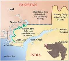
Sir Creek, originally known as Ban Ganga, is a tidal estuary that separates the Rann of Kutch to the east from Sindh to the west.
Unpredictable but important
The creek is unpredictable. Monsoon rains swell its banks. Venomous Russell’s vipers and scorpions hide in its marshes. The terrain is inhospitable and almost impossible to patrol.
And yet, both India and Pakistan see it as critically important.
As the news report highlights, over the years, Pakistan has built bunkers, forward bases, and radar posts here.
These are reportedly capable of launching drones and infantry operations.
India, too, maintains a strong military presence to deter any aggression.
Strategically, Sir Creek is considered vital to Pakistan’s defence of Karachi, its largest city and economic hub.
But the dispute goes far beyond military interests.
The estuary holds rich, untapped reserves of oil and gas. For both countries, it’s a gold mine.
For India, striving to reduce dependence on Russian oil and diversify its energy sources, Sir Creek also remains a zone for strategic importance.
Normalcy, a myth here
The creek is home to rich fishing grounds that support the livelihoods of thousands in both Gujarat and Sindh. But with no agreed boundary, fishermen often cross into each other’s waters unknowingly. Arrests are common. So are ruined lives.
The question of where the boundary is has consequences for both countries’ Exclusive Economic Zones (EEZs) in the Arabian Sea. EEZs extend 200 nautical miles from the coast and grant rights over marine resources.
The way Sir Creek is demarcated affects these zones.
The issue lingers
India claims the boundary lies along the mid-channel of the creek. Pakistan claims the entire creek.
At the heart of the disagreement is the Thalweg principle. For the uninitiated, it’s an international rule that draws boundaries along the navigable centre of a river. India argues that Sir Creek is navigable and falls under this rule. Pakistan disagrees, insisting that the creek is not navigable and the Thalweg principle does not apply.
The origins of the dispute date back to colonial times—specifically, to an argument in the early 20th century between the princely states of Kutch and Sindh over a pile of firewood on the creek’s banks.
After the 1965 war, Pakistan claimed half of the Rann of Kutch, including parts of Sir Creek. A tribunal in 1968 awarded India 90% of the Rann and rejected most Pakistani claims. But Sir Creek was left out of that ruling. The tribunal noted that “the question concerning the Sir Creek part of the boundary is left out of consideration.”
Since then, the issue has lingered.
The first talks were held in Islamabad in 1989. Both sides discussed core aspects of the dispute. Yet the talks remained indecisive.
Rounds of talks followed in 1990 and 1991, including meetings in Rawalpindi and New Delhi. Indian Navy technical experts attended the one in New Delhi.
In 1998, India and Pakistan formed a dedicated working group to resolve the matter. At a meeting in New Delhi that year, India strongly objected to Pakistan’s attempts to internationalise the issue. It reiterated that, under the Simla Accord, disputes must be resolved bilaterally.
Pakistan wanted to refer the matter to an international tribunal. But India’s then Joint Secretary in the Ministry of External Affairs, Vivek Katju, stated that arbitration was unacceptable under the terms of the ongoing composite dialogue.
In 2019, the Ministry of External Affairs confirmed that the last formal round of talks had taken place in June 2012. The two sides had discussed both the land boundary in the Sir Creek area and the delimitation of the maritime boundary.
A former member of the Parliament, the report outlines, said that a Comprehensive Bilateral Dialogue, including the Sir Creek issue, was agreed to in 2015.
Apprehensions of misuse
However, dialogues ended following the terror attack on the Pathankot Airbase in January 2016 and Pakistan’s support for cross-border terrorism.
Security concerns remain high. The apprehension is that the creek could be misused to infiltrate India.
As the report reminded, Pakistani terrorists arrived by boat during the 2008 Mumbai attacks. Similar attempts through Sir Creek cannot be ruled out.
For now, nothing is settled even as the tides rise and fall.
Also Read: Sleeping With Power: How ‘Apolitical’ is the RSS? https://www.vibesofindia.com/rss-and-politics/